
Tuesday, June 28, 2011
Update to Diagram
This is an update to the previous diagram that compares all of the selected buildings that were a part of my study.
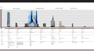 The diagram shows the visual relationship of all of the buildings that I have studied during this course: Times Square Tower, The Actor's Equity Building, The Time Warner Center, The Columbus Circle Building, Atlantic Terminal Mall, HL23, and The Church of the Guardian Angel.
Atlantic Terminal Mall
Atlantic Terminal Mall houses most of the activity that I observed near the site. Once we entered Fort Greene it was evident that most of the people that visit the mall are locals, and they tend to gather in small clusters around the neighborhood. This could be in part because of the large construction happeing in the area. Atlantic Terminal Mall has a transient relationship to its site and users. It is a major node for travel, Atlantic terminal is the third busiest terminal in New York, it is a place where people travel through but not necessarily travel to unless they where shopping. The mall occupies almost 300,000 square feet of space and houses popular mid income level retail stores such as Target.


Atlantic Terminal Mall: Height: 88m Building Uses | |
| - mixed use | |
| - office | |
| - restaurant | |
| - retail | |
| - station | |
| Structural Types | |
| - highrise | |
| Architectural Style | |
| - postmodern | |
| Materials | |
| - masonry | |
| - glass | |
| - steel | |
| - brick |
Atlantic Yards: Willamsburgh Bank Contrast to Atlantic Mall 2
Atlantic Terminal Mall
Atlantic Termiinal mall is the latest development near Atlantic Yards. My observations were as follows:
1. Construction wtihin the boundaries of Atlantic Yards.
Prospect Hieghts lowrise structures contrasts with the highrise buildings beyond and form a imaginary boundary along Flatbush by there stark architectural style and hieght differences.
Material changes occur within the side walks as New York's famous stone side walks are being replaced for concrete.

2. People gathered outside of Atlantic Center Mall to sit within the small public space
people gravitated more towards areas where there are people

 Example of how people tend to use the public space, no one sat on the other end of the stairs, although there is plenty of room, there were no people near.
Built: 2002
Building Uses: mixed use for office, restaurant, retail, station
Sturctual Types highrise
Architectural style: Postmodern
Materials: masonry, galss, steel , brick
Height: 88m
Floor Count: 15
A
Atlantic Termiinal mall is the latest development near Atlantic Yards. My observations were as follows:
1. Construction wtihin the boundaries of Atlantic Yards.
Prospect Hieghts lowrise structures contrasts with the highrise buildings beyond and form a imaginary boundary along Flatbush by there stark architectural style and hieght differences.
Material changes occur within the side walks as New York's famous stone side walks are being replaced for concrete.

2. People gathered outside of Atlantic Center Mall to sit within the small public space
people gravitated more towards areas where there are people


Built: 2002
Building Uses: mixed use for office, restaurant, retail, station
Sturctual Types highrise
Architectural style: Postmodern
Materials: masonry, galss, steel , brick
Height: 88m
Floor Count: 15
A
Atlantic Yards: Willamsburgh Bank Contrast to Atlantic Mall 1
One Hanson Place, also known as the Williamsburgh Saving Bank Tower, is an Art Deco Romanesque building that during its time, dominated the Brooklyn landscape. It was built in 1929 as a residetial/ office building. The materials of the building are masonry, steel, lime stone, and gold (dome). The AIA Guide to New York City says, "inadvertenlty, this was new york's most phallic symbol... dominatin the lanscape of all Brooklyn." it stands at 512 feet (156m) tall, and is the 3rd tallest buiding in Long Island and one of the tallest four sided clock towers in the world.

Today it is a landmark that can be seen from the ground, a great distance away. Its location, it was built during a time when Brooklyn was begining to develope and had little impact on the surrounding buildings that it dominated due to its
Built: 2000-2004
floor Count: 57
Structural Type: Highrise, Atrium
Architectural style: Modern
Materials: Glass, steel, granite, concrete
Building Hieght: 229M 751.31FT
Architects: Skidmore Owings and Merrill LLP
BUILDING USES
- MIXED USE
- HOTEL
- OFFICE
- OTHER
- RESIDENTIAL
- RESTAURANT
- RETAIL
- THEATRE
Times Square: One Times Square Building and The Actor's Equity Building

From visiting the site, One Times Square is on an North-South Axis that is visble by both pedestrian and vehicular traffic. The Times Square Tower rests just behind the historic One Times Square, covered in signage. The Actor's Equity Building, also a historic building at the site has a different relationship to the observer, its side is used for advertisement and in some way had an advantage to the tower in that it is able to use two sides for display upon approaching traffic whereas The Times Square Tower and One Times Square side views are blocked by adjacent buildings.
One Times Square
Built: 1904
Roof Height: 395ft (120m)
Floor Count: 25
Structural Type: High rise
Cyrus L.W. Eidlitz, James C.
Developer: the New York Times
Architectural Style: Art Deco
Materials: granite, terracotta, marble, concrete paneling
Building Use: Office for The New York Times later
Times Square Tower
Built: 2004
Roof Height: 726ft (221m)
Floor Count: 47
Structural Type: Highrise
Architects: Skidmore, Owings and Merrill
Delveloper: Boston Properties
Materials: Glass, steel, concrete
Building Use: Office, retail
The Actor's Equity Building
Built: 1924
Roof Height: 202ft
Floor Count: 17
Structural Type: Highrise
Architects:McKim, Mead, and White Architects
Materials: Blass, steel, concrete
Buildng Ues: Office Restaurant
Abstract
Introduction
Buildings account for 40% of the green house gases emitted into the global environment. I seek to expand upon the incremental progression of knowledge on how urban development patterns affect our environment overtime and how those changes may affect our environment in the future. My research is a focus on comparing the transitioning between the oldest historic buildings to the newest development in each of our site locations: Columbus Circle, Atlantic Yards, Times Square, and The High Line in terms of scale, usage, and social impact over time. With this I hope to understand how large scale-influential projects transitioned within each location and to document the socio-economic and architectural conditions that impacted each succeeding development. I hope to gather specific data on site conditions, leisure activities, building typologies, and background research to demonstrate the societal impacts of each site. From this information I hope to then produce a more detailed story into how and why we have developed and where our cultural impacts have led.
Methods
§ Field visits to gather information through observation of pedestrian use of the site, record data in a spread sheet to compare sites.
§ Research historical and modern building types and chart materials, structure, uses, etc.
§ Diagram and chart activities and development patterns
Results
After charting the materials, site impacts, and evaluating the use patterns during each site development I noticed a trend in the need for taller structures to accommodate population demands, the movement towards greener building, and architectural styles following significant social changes in the U.S. After charting the activities at each location, I noticed that the buildings surrounding the sites significantly impacted the sites’ focal range, activities, and use of space.
Conclusion
The High Line is an example of an anti- thesis to the perception of bigger and stronger. After studying its program and development, there were no oppositions to its development, as a natural resource, it provided what the large scale structures seem to take away: the human scale, a sense of space and place, and visual continuity. I conclude that as a nation we are transitioning from a need to express the might of our nation to a realization in the finite application of consumption; a need for conservation and adaptive reuse have become more evident.
The Building Contrasts
The HL23 building is one of the newest developments along the High Line. I choose this building due to its unique shape and position on the walk path that creates a slight overhang that adds a definition to the space around the building in its relation to the other buildings within sight. The HL23 was designed by Neil Denari, a California Architect that designed one of the most ambitious buildings in Manhattan. The resolution to setbacks for the parcel is ingenious as the narrow footprint widens as it goes up. The HL23 is a 14 story condominium designed in a structural expressionist style that articulates the structural elements of the building form as part of its aesthetic feature. The building protrusion over the park contrasts with the one of the older buildings along the path, The Church of the Guardian Angel.

The Church of the Guardian Angel was built in the 1930s by John Van Pelt. The longest side of the building faces South to the High line.

http://www.homedesigninterior.org/tag/hl23/

The Church of the Guardian Angel was built in the 1930s by John Van Pelt. The longest side of the building faces South to the High line.

http://www.homedesigninterior.org/tag/hl23/
The High Line Transitions 2
In the proceeding images I intend to showhow the building heights contrast with the public space and the visual emphasis they project on the public space. The buildings are not a hinder to the focal range but rather participates in the experiential process of pedestrian movement by providing observatory objects that flank the flow of movement rather than inhibiting it or creating a sense of enclosure but instead accentuates the sense of movement.
A. Ganersvoort Entrance

B. Near 14th Street Entrance

C. Section 2 viewing area.

D. Section two walk over.

E.

Bibliography:
http://www.emporis.com/application/?lng=3&nav=building&id=322690
http://archinect.com/news/article/9106134/a-first-look-at-section-2-of-new-york-s-high-line-park
http://blog.ohny.org/2011/06/13/field-trip-friday-section-2-of-the-high-line-is-open/blog1-hl-sec-2-2/
The High Line Transitions
The buildings that I decided to study on this site where the buildings, historic and modern, that interconnect in some way to the public space. Due to the nature of the site, most of the buildings had little impact on the sunlight exposure, line of sight. They do provide a sense of enclosure and visual interest.
In the activity zones diagram below you will find a very organized programming that went into the design of the high-rise park.

Programming
Similar to the other site visits, the clusters of social activity were either programmed by the site or by the people that use the space. The Highline has both strategically planed activity zones while some spaces were improvised mainly for performace events. The high line has regularly scheduled events and it is less likely that you would encounter an unplanned ostentation. Which makes it predictable and not as public as it could be. What really makes the Highline different from the other public spaces is that it generates movement, you cannot experience the park without moving through it, it becomes like sort of a highway of leisure activity where the other sites were more destination focused: one travels on a route leading to the public space mainly to sit and observe, socialize, and participate in an activity taking place. The High line encourages physical activity. One would want to walk along its length because the visual focal point is not within a broad visual range rather along a myopic linear path that transitions from one experience to the next; carnally playing out along its course; allegorically, a visual play of events outside of the would be train window.
Woman enjoying the sun and water feature.

Before development, Pre 2005 redevelopment


Bibliography:
http://www.ecuadortimes.net/2011/06/14/new-york-opens-highline-park%E2%80%99s-extension/
Monday, June 27, 2011
Observations
From studying the site, I was able to analyze how the two buildings compared to the site in terms of visibility and how they may have impacted the site. From my observations, The Time Warner Center is a major point of desination for most users of the public space. Most of the pedestrian activity took place along the curve of the Time Warner Center where people gathered to meet company, talk, and eat either before entering the space or having left. The diagram above illustrates this activity. In the pictures below I attempted to capture the visibility of the circle from the accompanying directions.

A. 813 8Tth Avenue

B. 1992 Broadway

C. 661 8th Avenue

D. View from the Grand Army Plaza
Bibliography:
http://goodnightraleigh.com/2011/06/apples-spaceship-campus-proposal-looks-familiar/
Wednesday, June 15, 2011
Round and About
Columbus Circle Is the first roundabout in the history of the world. It was completed in 1905 and renovated in 2005, a century later. Understanding the history of the site will give some insight into use patterns and what contributing factors led to specific renovations. Like many of the sites I am studying, Columbus Circle presented a major impact on the surrounding community, both positive and negative. As a major landmark in New York City, it is a point of attraction, dispute, and a datum for some of New York's main streets. The monument of the circle, named after Christopher Columbus, was created by Italian sculptor Gaetano Russo and erected in 1892, New York's commemoration of the 400th anniversary of Columbus landing in the Americas. The inner circle is approximately 36,000 square feet (3,300m^2) and the outer circle is approximately 148,000 square feet (13,700s m^2). Adjacent to the circle are four major buildings: The Time Warner Center, Museum of Arts and Design, Trump International Hotel and Tower, and Central Park South. Most of the buildings adjacent to the roundabout are fairly new. To study "historic" buildings I will adhere to the definition of historic by the Historic Preservation Act of 1966 which states, that is, districts, sites, buildings, structures, and objects significant in American history, architecture, archeology, engineering, and culture. that acknowledges significance at the local level "historic properties", that is, districts, sites, buildings, structures, and objects significant in American history, architecture, archeology This inclusive approach and broad definition have enabled those concerned with public archeology and archeological preservation to work within the general umbrella of the national historic preservation program.
Bibilogrophy: http://en.wikipedia.org/wiki/Columbus_Circle, http://www.preservationnation.org/
Columbus Statue at the center of the round about.
This is one of the most historical buildings on the site. 1841 Broadway, also known as The Columbus Circle Building was built in 1924 by H.H. & C.N. Whinston Architects. The Beaux Arts Renaissance Revival building supports 12 levels on a 117,115 square foot project area and mainly served to house office spaces.
Columbus Circle 1933.
The Time Warner Center is the newest development on the site. This high-rise structure supports 57 floors for multi-use including: hotel, office, residential units, restaurant, retail, and a theatre. It was designed by Skidmore, Owings and Merrill LLp in 2004. The materials that make up the exterior are glass, steel, granite, and concrete. This modern building received tremendous backlash from the surrounding communities, mainly "Hell's Kitchen" located just South of the building.
The highrise building is can be seen from a far distance, making it an asset as a way finding landmark for the circle that the statue alone may not be able to reach.
Bibliography:
http://theboweryboys.blogspot.com/2009/08/pre-trump-columbus-circle-1933.html
http://www.flickr.com/photos/anomalous_a/5358954831/meta/
Development Study
This is a working diagram of the buildings that I plan to focus on and their surrounding areas. I gathered from this study that the varying compositions and heights are contributed to both community and developer planning. However as the century began to turn more development was being controlled by outside entities, developers and city aspirations that almost always conflict with community interest.
At The Crossroads
Times Square is located at the intersection of the borough Manhattan and New York City and at the junction of Broadway and Seventh Avenue. It stretches west towards 42nd Street and 47th Street. It is the heart of New York's Theatre District and has become a global city for tourism, business, and entertainment. After The New York Times moved its new headquarters at 42nd and Broadway in 1904, the original name of Long acre Square changed to Times Square. The Times Building, now called One Times Square is the location of the New Year's Ball Drop. By 1930s, commercial real-estate began to flourish, with 20 new skyscrapers; this was also a time of crime and corruption. This atmosphere of danger began to change in the 1980s with the help major development under Mayor Ed Koch and David Dinkins. Crime was uprooted from their main sources, new infrastructure began to evolve, and Walt Disney purchased over __ of New York City real-estate, making Times Square a major anchor for the city and what some may say, "Disneyfied" Times Square.
Theatre District
Big, bold, and bright became a signage a zoning requirement in Times Square.
1904 image of Times Square Broadway at 42nd St in 1880.
Bibliography: http://goodnightraleigh.com/2011/06/apples-spaceship-campus-proposal-looks-familiar/,http://wirednewyork.com/forum/showthread.php?t=21249&page=4,http://www.nyctourist.com/history1.htm,http://webcache.googleusercontent.com/search?,q=cache:HdWSQkrp0TMJ:www.nps.gov/archeology/tools/Laws/nhpa.htm+historic+preservation+act+definition+historic+properties&cd=3&hl=en&ct=clnk&gl=us&client=firefox-a&source=www.google.com, http://www.nyc.gov/html/dob/downloads/pdf/signbroch.pdf
Photos taken by: Nyasha Felder
Friday, June 10, 2011
Saturday’s Field Visit
This Saturday I will be returning to New York to study our next site, Times Square and to revisit our first site Columbus Circle. Our first week at Columbus Circle was a holiday weekend and I did not want to include the inconsistent variable of traffic that included many visitors that you would otherwise not see on an average day. For this next phase of the research I will be assessing the transitioning between the oldest historic buildings in each of our locations to the newest development in terms of scale, by comparing building heights, socio-economic impacts and capital, building design (square footage, foot print, etc), distances to street edge and local transportation (which may also fall under usage).
To study the usage, I plan to observe the activities of the site by the local inhabitants and visitors by charting clustered activity where people may convene to eat, socialize, play, observe, work, etc.
The materials and style of each building will also be recorded by observation and through researching soft data on the building's history. All of the data that I will acquire over the next few days will hopefully demonstrate the social impacts of each project to understand how large scale-influential projects changed within each location, and ultimately to better understand the significant changes that occurred impacted the success had over projects and the impacts of mega projects on the surrounding communities over time.
Subscribe to:
Posts (Atom)